
To: Bluedot Living
From: Jinsu Elhance, Conservation Technology Associate at The Nature Conservancy
Subject: Researching water dynamics through data collection and mapping
Every drop of water and every byte of data has a story, interwoven with the tapestry of our environment. Both possess the power to shape the world around them at each stage of their life cycles. As rainwater disappears into the earth before flowing through creeks and rivers, its journey parallels the flow of data among conservationists, researchers, land stewards, and policymakers. Each step in this data cycle contributes to our understanding of water and its conservation. At the Jack and Laura Dangermond Preserve, The Nature Conservancy’s preserve in Santa Barbara County, where native ecosystems have been protected from extensive development, scientists are pioneering a concept known as the Freshwater Digital Twin — a groundbreaking tool that merges the narratives of water and data into a transformative whole.
A “digital twin” is an interactive 3D map of a system. While these models have been developed primarily for urban infrastructure, the Dangermond Preserve is pioneering their application to complex natural environments. The Freshwater Digital Twin is an online map on which researchers, land-managers, and other conservation workers can observe a real-time representation of the preserve’s hydrology. Users can click on points representing sensors installed in streams, tanks, and wells to download the most current data. Users can also view how the preserve’s water dynamics change under different climate scenarios, which the map visualizes.
“The data we collect in the field, much like a drop of water, possesses its own unique story. It flows among conservationists, researchers, land stewards, and policymakers, informing their work and thereby creating an impact at every step of its journey. Just as water is essential to life, this data will ultimately contribute, in its own right, to preserving the well-being of our planet.”
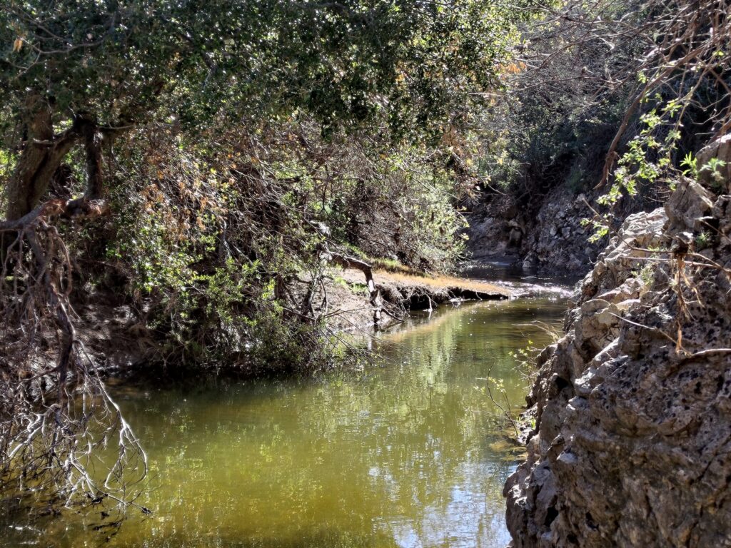
The Dangermond Preserve, encompassing 24,346 acres of protected land, serves as a living laboratory where scientists delve into the mysteries of California’s ecosystem dynamics. Nestled at the convergence point of marine and terrestrial ecosystems along the state’s coastline, it holds the key to unraveling the intricate relationship between water and life. Within the preserve lies the Jalama watershed, meandering through hilly canyons and lush vegetation before ultimately merging with Jalama Creek and the vast ocean. This setting presents an unparalleled opportunity to study the water system holistically. It is here that I embark on a mission to collect data throughout the basin, constructing a digital model that captures the preserve’s water dynamics. This distinctive interpretation of the Digital Twin concept enables us to observe and study the natural environment through a digital abstraction. The future of groundwater in California hinges on the quality of analysis conducted in such invaluable initiatives.
In my prior life as a data scientist, my curiosity was immersed in theoretical models and algorithms. However, I yearned for data science applications that facilitated meaningful contributions to our planet. In my job as a Conservation Technologist at the preserve, I draw upon my knowledge of environmental science, statistics, and technology to address broader questions about how to achieve a sustainable future. Now that I work in the field, I spend my days surrounded by the captivating beauty of untouched landscapes. Venturing into the field allows me to collect data that will underpin the construction of the Freshwater Digital Twin. Our digital twin relies on a water budget model to enhance our comprehension of the intricate relationships between precipitation, streamflow, and groundwater storage.
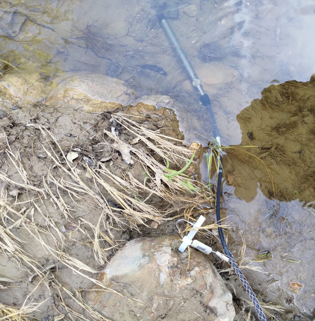

Today, my journey takes me deep into the chaparral, surveying wells and deploying sensors in riverbeds, capturing the unique stories within every droplet of water. By collecting data from precipitation patterns observed by weather stations, estimating streamflow through an intricate model developed by The Nature Conservancy, and monitoring groundwater levels with pressure transducers installed in wells, we weave together the threads of water’s narrative.
“Today, my journey takes me deep into the chaparral, surveying wells and deploying sensors in riverbeds, capturing the unique stories within every droplet of water.”
I embark on an early morning expedition, traversing winding roads in an ATV laden with well-survey equipment. As I arrive at each well, I carefully brush away foliage to deter rattlesnakes before removing the cap from the casing. Spending hours meticulously recording the conductivity, temperature, and depth of the water, alongside details about the sensor, the surroundings, and any noteworthy observations, I capture the essence of each well’s story. When I’ve finished, I download the data onto a field computer, from which I’ll later upload it into the models within the digital twin. Finally, the sensor is redeployed or replaced, continuing its data collection until the following year.
Like my personal journey intertwining data science and environmental science, the development of valuable digital abstractions like the digital twin hinges on ground truth. The data we collect in the field, much like a drop of water, possesses its own unique story. It flows among conservationists, researchers, land stewards, and policymakers, informing their work and thereby creating an impact at every step of its journey. Just as water is essential to life, this data will ultimately contribute, in its own right, to preserving the well-being of our planet.